A
BRIEF HISTORY OF
ANDERSONS
BAY,
DUNEDIN
Whatungarongaro te
tangata -People
perish,
Toitu te whenua -
But the land is permanent
Home ///////////////. Bain murders ///////////////.Andersons Bay Services ///////////////.Linkspage
|
Andersons Bay, the hillside Ngai Tahu Maori called Puketai, got its European name from the fact that the first white man to live there was Mr James Anderson, who came from Nelson to Port Chalmers on December 30th 1844, and continuing his journey up the harbour looking for a place to settle, discovered the Bay and built a whare amongst the flax at the junction of what is now Somerville and Silverton Streets. Andersons Bay was formed as "the result of the land sinking below 1000 feet and the sea entering two river valleys to form the harbour as we now know it. Later rivers such as the Taieri and the Clutha deposited eroded materials in the sea with the prevailing currents carried north-easterly to deposit and create the narrow isthmus between the sea and the harbour, forming an extensive mud-flat. Former inlets of the sea became land-locked to leave traces of their origin - a former island, Sunshine and part of Musselburgh, and the cliffs of Tainui and Bayfield .By the time of European settlement the Andersons Bay district was described as being of bush-clad hills, flax-covered swamps and an indented low-lying harbour and coastal shoreline. -Tyrell (2000) Taylor(1998) attributes the name Puketahi; (meaning "the hill which stands alone" to the hill now called Sunshine, opposite Andersons Bay. "Before the Europeans arrived in New Zealand, Maori hunting parties would row their canoes down the South coast and take a short cut by coming right down the harbour from Aramoana to the Tainui Inlet, about where the gates of Bayfield High School are now. They would camp on top of Puketahi so that they could keep watch in case raiding tribes attacked them. They would continue their journey by carrying their canoes overland to St Kilda beach, and start rowing (sic) South again". Taylor (1998) There was a large quantity of game on the Peninsula when the first settlers arrived. This was a great help to them when provisions were scarce and dear. One had only to go a little way into the bush to get as many kakas and pigeons as were required. There were also quail and woodhens and thousands of tui, which were very good to eat. One season there was such a great number of kakas that they became a regular pest, eating the grain and turnips in the fields. Nothing came amiss to them. They sat on the fences and were so tame that many were caught by boys with flax loops, or they knocked them over with sticks and stones. Some years the parakeets also were a plague, eating and destroying a lot of grain crop and fruit When the pioneers first arrived the Bay was a very pretty spot with scrub and flax growing near to the water's edge and the bush in the background. There were some very heavy trees on the ridges and the settlers had no easy task before them to fell, burn, log and grub the roots from the ground; but they were made of the right stuff. The Tomahawk, or Tomahawk as it is now called, was settled a little later than Anderson's Bay. Mr James Patrick a passenger on the Philip Laing, was the first person to make a home in the bush beyond the lagoons in 1857. We may note that Tomahawk is probably a corruption of Tomahaka (toma- burial place, haka, dance); and that Puketahi, kept alive by the Puketai Street that overlooks Tomahawk lagoon, was applied to some part of the Andersons Bay district. It is generally agreed that the original form of the name was Puketahi (puke-hill; tahi- by itself). Tradition has it that Puketahi was actually a former pa, and if this is so, its name- like that of any European settlement or homestead, could have come from anywhere. 'Goodall and Griffiths (1980) The Maoris used to travel overland along the coast, getting shellfish from the rocks and eels in the lagoons. Their old track could be seen along the sandhills from St Clair, through the site of the present cemetery. From there the track was along the lagoon over the Tomahawk hills, down into Sandfly Bay, up over the Sandymount, down to Hooper's inlet and Wickliffe Bay and on to the kaik. There were various cooking places along the way. They were little wider than a sheep track, were worn to a depth of several inches and in dry weather full of leaves. " It is generally agreed that the neck was very narrow in earlier times, one of the irregular harbour inlets may well have run to within 200 or 300 metres of the coastline' p17 'Goodall and Griffiths ( 1980) (from beneath Sunshine Hill probably by the Dunedin end of the causeway to the beach at St Clair). The old Tainui inlet, long since filled in, brought the harbour up to lap Musselburgh Rise within living memory; and 150 years ago, probably reached well up the low-lying gully towards Spottiswoode Street. The population expanded early in Andersons Bay, and there was a school from about 1851 at Ross's Corner where Archibald Macdonald was the master. In 1872 the school was removed to Silverton Street. The Andersons Bay Road Board was formed in 1856 and its principal task was to build the roads previously surveyed by Charles Kettle from the Oval through to Andersons Bay. Haward notes (2001) that William Somerville built their second house in the Bay called "Charlsefield" in 1865 at 56 Somerville Street, Andersons Bay; their first house being built in 1848. The corner of Silverton and Cranston Streets is known as "Ross Corner" after Hugh Ross, publican of the large Anderson Bay Hotel which stood there from 1864 to 1905. The hotel was dismantled in 1905 to make way for the trams, and hauled up by sledge and rebuilt at 14 Tomahwak Road ( it now stands as a large two storied house). The corner of Tomahawk, Silverton and Highcliff Roads was named the Terminus for the electric trams which ran from the city from 1927 until 1952. On the opposite side of Tomahawk, the "Terminus Shops" used to include a drapery, cale shop, butcher, chemist hairdresser, fruiter, bootmaker and doctors rooms. Hayward (2000) The railway to Andersons Bay, the "Peninsula and Ocean Beach Railway”, was begun on Christmas Eve 1874, and the line opened to the Beach on 26th October 1876 and to the Bay on 14 January 1878, and was described by the Evening Star (14th January 1878) as the "first section of the main line to Portobello". The trains ran to the Bay via Forbury and some to Forbury via the Bay, using two engines the General Nigel, and the Edie Ochiltree. Later the line was used for the steam trams. A branch line at the junction of Andersons Bay Road and Portobello Road wet round the base of Sunshine cliffs onto what is now called Shore Street, to a railway station at the base of Silverton Street. The line ran a short distance further along Somerville Street area to a water tank, engine shed and inspection pit"; Taylor (1998) With the increase in popularity of horse trams, interst in train travel wained and the Andersons Bay train line closed in 1882. "A 3ft light gauge railway was constructed by Thomas Begg in 1905. The line ran from the intersection of Shore St and the Causeway, following the foot of Sunshine Hill, skirting Tainui Inlet before crossing Musselburgh Rise to run under the loading bins of Andersons Bay Quarry and Brick Co Ltd. (Now called Dunford Place Pensioner Settlement, opened 1984). That line gave way in 191l to a 3ft 6in line, opened in 1912, which ran along Shore St for transport of stone for the Southern Endowment retaining wall across the Otago Harbour, (now Portsmouth Drive). Work in that area stopped in 1921 and the lines were lifted in 1928."-Taylor (1998) The Presbyterians had a church built in Andersons Bay by 1863, previous to which they held services in the schoolroom. The Anglican church of St Michaels was put up in 1871 at Shiel Hill. Some of the early shops and trades at Andersons Bay were the bakery, a butcher shop, a smithy, a draper, a hotel from 1864 to 1865 and a boot repair business. The causeway across the Bay from Cutten's Corner to the old Quarry Reserve (or Vauxhall Corner as it is now known) was commenced in 1870, with the bridge completed in 1872. Taranaki Maori captured at the peaceful settlement of Parihaka, provided the bulk of the labour in both building the stone causeway and some of the sea walls alongside the Peninsula road. Their presence in Dunedin is commemorated in the stone Rongo monument at Cutten's Corner. In 1890 the steamer ferry, the Pioneer, under the management of the Andersons Bay Ferry and Baths Company, commenced from Cross Wharf in Dunedin to the old railway station at Andersons Bay. The inlet was dredged to 7 feet and the causeway road bridge made to raise. However after a short time in service the business folded after passengers deserted the ferry because of late arrivals at work resulting from delays caused by the tides and the ferry getting stuck on the mud flats The "Bay Town Board" was constituted in 1905 to administer Andersons Bay, but amalgamated with the Dunedin City Council in 1916. The Catholic religious order, Little Sisters of the Poor, built a massive brick building in 1903, occupying an area now called Glenfinnan Place to cater for the frail and unfortunate of the time. It had three stories, with glassed in corridors, a round ended chapel and "bells whch rang with such regularity that Bay dwellers seldom looked at their clocks"-Taylor. The building dominated the Andersons Bay skyline for 75 years until its demolition in 1978.Karitane Hospital, 79 Every Street, Andersons Bay. After a two year campaign to improve the care and nutrition of children, Dr Truby King held a public meeting in the Town Hall, Dunedin, on May 14th 1907. This marked the formation of the Plunket Society of New Zealand. Shortly after that meeting, Mr Wolff Harris leased a six roomed villa and more than three acres of surrounding land to the movement. The villa was converted into the Karitane Hospital. When the lease ran out, Mr Harris donated the whole complex to the Plunket Society, and the hospital then took on the name Karitane Harris Hospital" Taylor (1998). "The Truby King-Harris Hospital (also known as the "Karitane-Harris Hospital" or the "Karitane Home for Babies") was established in 1907, the first of the Karitane Hospitals. It was set up for the treatment of sick and ill-nourished babies for whom ordinary hospitals were unsuitable. Until 1979, it was the training centre for Plunket nurses in New Zealand". National Register of Archives and Manuscripts. The Hospital closed in 1978 and was then converted into the Andersons Bay Home and Hospital for frail older people, until its closure in 2004. It has since been converted into budget accommodation for travellers.("Every Street Lodge"). 41 Every Street, Andersons Bay is the former home of the Every family, where the house known as Silver Acres" was built in 1858 by Simon Avery, fourth son of an English baronet, and later re-built by his son John Every in 1888. |
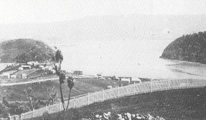
Andersons Bay from Highcliff Road: 1870s
Andersons Bay 1870s

Andersons Bay: 1900
Causeway and Harbour Sea Walls
Built Up by Prison Labour
(From: the Otago Daily Times of Wednesday, 18-April 2001)
By Allison Rudd
|
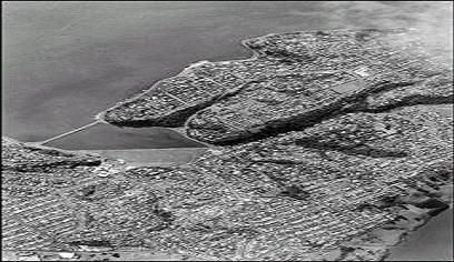
A recent aerial shot of the Andersons Bay and Vauxhall areas prominently shows the Andersons Bay inlet and causeway. The cluster of buildings at centre left is Bayfield High School, with the reclaimed Bayfield Park immediately behind it. (2001 Otago Daily Times). The causeway was built 130 years ago to provide road access to settlements at the harbour edge. The only other route to the well settled peninsula at that time was the "high road" (over the Peninsula hills). Dunedin archaeologist Jill Hamel, who researched the history of the harbour sea walls and causeways in 1997 and 1998, said the causeway was built using prison labour. According to prison records, some of those prisoners were Maori political prisoners of war transported to Otago in the late 1860s during the wars in Southern Taranaki. Their crime was to resist the colonial armies, which were trying to gain control of the area so it could be opened up to European settlers. "The Maori believed they were defending their land from white invaders," Dr Hamel said. Maori prisoners were transported to Otago to serve their sentences right through until the 1880s, she said. Most worked on building parts of the stone walls, which stretch about 34km around the harbour edge from Taiaroa Head to Te Ngaru, near Aramoana. |
|
Early Maori Settlement in Otago began with the tribal grouping of Te Waitaha and Te Rapunai: now collectively known as Waitaha. Tradition has it that they arrived in the canoes Te Ari I Uru and Te Uru Ao. Although archaeologists place the date of arrival at about 850-950 AD, some of the oral traditions of Maori suggest a much earlier time of arrival, as may be indicated by the recent carbon dating of Polynesian rat bones (which could only have been brought via human migration), at approximately 0 AD. The Waitaha were possibly the first Polynesians to have settled in New Zealand. To them the South Island was Aotearoa, and the North, Te Whai Repo. Their traditions say they came from Easter Island, rather than the Cook Islands of later Maori migrations. Many of the Maori names for geographical features throughout the South Island carry the names of Waitaha ancestors or a Waitaha historical event. In the 1500s (AD) a section of the Ngati Mamoe tribe, (whose ancestral lineage or 'whakapapa' is traced back to Paikea who was born on the Tahitian island of Rai'atea in the early 1300s; later travelled to the Cook Islands and then on to New Zealand) from the Gisborne area of the North Island, also crossed Cook Strait to settle in the South. Not being of great numbers, they successfully intermarried with Waitaha, and settled throughout the South Island. In the late 1600's, a sub-tribe (or hapu) of the Ngai Tahu tribe in the Wairarapa of the North Island, after causing the death of one of their relatives in another sub-tribe, decided it would be better to avoid feuding and migrate to the South. With agreement from Ngati Mamoe they settled in Kaikoura, (north of Christchurch). Later more Ngai Tahu followed from the North settling across the South Island and upsetting the peaceful balance. Fighting between Ngai Tahu and Ngati Mamoe/Waitaha continued for many years. A peace settlement was finally negotiated in the late 1700s between the main families of Ngai Tahu and Ngati Mamoe through an arranged marriage. However some descendants of the Ngati Mamoe and Waitaha in the south refused to be bound by this pact and the conflicts continued, until almost all were eventually killed. A Description of the Otago Peninsula Before the Bush was Cleared (1859) "With the exception of a few small clearings, all the country between Purakanui and the Otago Harbour and the sea, was dense forest. Large timber trees with lovely evergreen leaves, and thick underwood of shrubs, which was always termed scrub. It was alive in the (18) fifties with birds, all native, as no imported birds had then trespassed on their solitudes. The kaka is the first to wake up, even as the first streak of dawn appears in the eastern sky. The lovely notes of the bellbird (Korimako or Makomako) awoke the light sleeper at daybreak with its sweet ringing chimes. The Miromiro (Pied Tit) would call with a sweet whistle of one note. The saddleback (Tieke) was not common, but occasionally one would hear the noisy male bird whistle pleasantly. The now rarely heard Kokako (native crow) had five sweet notes like a clear, well sounded flute. The useful flycatcher, the pretty fantail (Piwakawaka) cried in a sharp pleasing note. The peaceful, and plentiful wood pigeon, then called Kereru or Kuku, from its call, cooed soothingly on the upper branches. After the sun had set the brown owl made its presence known calling "more pork". Occasionally, the air at night would resound, and the hollows of the rocks echo back the thrilling sound of the laughing owl or jackass (Whekau), not a pleasant sound on a dark night." "A Pakeha's Recollections"-MG Thomson Waikouaiti and Dunedin in 1850: Reminiscences of John McLay, an Early Settler We have got over to Andersons Bay. We left Rattray Street on Saturday. Hutton took our things from the house we were living in to the wharf, and Mr Sam Woolley and son took us over the river (Otago Harbour) to the house that Mr Archibald Anderson put up and lived in it for a while. The house stood up on a clay terrace above the Water in this bay. The house was a two roomed house made of clay. There is other two families living a little to the north of this along a little flat close to the bush. Their names was Begg and Somerville. They had been out from ‘home’ about nine months before us, this bay takes its name from Anderson. This shift is the second one since we arrived in Otago, and the day we shifted from Rattray Street makes the third Saturday we arrived in Otago. And by what I can hear from father and mother that we will have another two shifts yet before we can get into the house that is yet to be built for us. You can see the house from Dunedin. It is a very sunny place - it gets the sun all day. I have never seen a Maori since I came over here. I used to spend a lot of my time with them before I left Rattray Street. I got quite fond of them, and some of the boys that could speak English that showed me how to make flax boats. I got to be quite an expert at this and sailing them.. Over here it is a splendid place to sail these boats, as you can wade out in the bay for a long way when the tide is in, on a nice level smooth sandy bottom , after the boats. I often wade out to see how far I can go before it gets too deep. It was nice to wade in this very clear water for hundreds of yards out to see such lots of crabs running over the bottom, and if you stood there for a little they would come and nip my toes. It was a fine time. These little beggars could give a good nip, and you could see thousands of little penny winkles in their shells moving slowly over the sandy bottom. And when the tide goes out , the crabs got into their holes until the tide comes in again. In one of my excursions I got a great fright with an octopus. It is a very ugly thing with long feelers 6 or 8 feet long with a row of suckers down to near the points of these feelers - from an inch down to about the size of a shirt button. They have such an ugly head with large eyes and in the head is a great lot of inky fluid that they can squirt out into the water to hide them from their prey - and under a part of the head they have a big black bill like a parrot, and they can swim fast and they look terrible when swimming., the feelers shoot out in front of their back in movement and all these eight feelers seem to go into one, and in the water, lying still, they look like a man. I was out in the water up to my waist when I saw this - my first octopus. I don’t think I need to tell you that I did not waste any time in making for shore, but it did not offer to harm me. But to make up for the great fright I got a few days after, a very agreeable surprise in seeing a wonderful kind of bird swimming away out near the rocky point (Vauxhall Point). When I told my people, they could not make out what kind of a thing it could be. My father got talking to the man that was working with him and he told father it would be a penguin. None of us had seen one, and to our surprise a few days after I had seen it swimming, it came back on to the beach below our house. I went to the beach a while after we all had got breakfast. What did I see but the penguin sitting pruning its feathers and basking itself in the sun. I went to catch it, but it did not seem to mind until I put my hands on it to catch it. Then it gave me a very sharp nip with its strong bill. After, I kept a sharp lookout not to get another nip. I managed to get a hold of it and carried it up to the house and Mother and my brothers and sisters had a good look at it. I tethered it for a few days, then my father and mother wanted me to let it go, but I did not want to do this, but I made a long string of flax and I took it down to get a swim when the tide was in. And it seemed very pleased to get into the water again, and it swimmed out to the length of the flax tether not so bad, but when it got to the end of the tether it struggled to get further out. When it could not get further, it turned to the right, and swimmed as far as it could, and after some bother it managed to swim back the other way, but it could not swim right through the tether, and it still wanted to get further out into the bay. So when I saw this, I felt sorry for it. I then gently pulled it back to me. I waded in and caught it and undone the flax and let it go. And it was not long in swimming out of sight. They can swim wonderful fast. And two or three days later we got a great surprise to see it come waddling up the pad that was from the river and we did not take notice of what it would do. It came right up to us. Then we all got round it, brothers and sisters and mother greatly taken up with it coming back, and we fed it with crumbs or anything we had as we had before. It did not seem to be the least particular what we gave it. Some times we had fish, and when we gave it some, it seemed to enjoy it very much. It is fish they mostly live upon. It used to go down from the house to the water in the bay every day and go away all day swimming - but it always came back. And it got to be lot of trouble to my Mother, as she could not keep it out of the house when the door was open. Early Otago and Genesis of Dunedin; Letters of Rev. T. Burns DD 1848-1865 "I have chosen nine suburban sections in what has been called the Andersons Bay district, which is right across the harbor in the neck of land which separates the harbor from the Pacific. At the end of the ridge where it rounds into Andersons Bay the sides are composed of a large mass of free stone for many feet above the level of the harbor, with the top densely wooded. This end of the ridge the Company have reserved for a quarry. It is very rich, flat land all along the top of the ridge, and it is a peculiar feature of the country that the Maoris choose these summits of headlands uniformly for their potato gardens. I was induced to choose in this locality, not altogether from the great beauty of it, the fine timber and the rich land, but mainly because the water communication (which is one and half miles across) makes it the most accessible of all the suburban lands except the meadow. There is a further advantage, that the bank of sand is composed entirely of shells, which will make excellent lime, for there has been no limestone discovered as yet. Moreover, it is sloping in the most beautiful way to the sun, so that it will be first-rate for tillage, and where it is too steep for the plough it will make beautiful pasture. It is at present the resort of all the wild pigs, wild calves and cattle, because of its sunny exposure and excellent herbage. On walking over it, one chief cause for the partiality of the animals to the Bare Point, as it is called here, is the presence of great quantities of anise (aniseed) plant, so gratifying to sheep and cattle that they will not look at any other herbage, and of so powerful and pleasant a fragrance that it imparts a peculiarly high and very agreeable flavor to the meat" -1848 Bibliography: Burns, T. Rev., Early Otago and Genesis of Dunedin; Letters of Rev. T. Burns DD 1848-1865, R.J. Stark & Co. Ltd Dunedin, 1916 Duckworth H., Early Otago History of Anderson's Bay from 1844 to December 1921 and Tomahawk from 1857 to March 1923, Coulls Somerville Wilkie , 1923 Goodall, M. and Griffiths, G. Maori Dunedin, Otago Heritage Books, Dunedin 1980 Gordon, R. S., (Editor), Waikouaiti and Dunedin in 1850: Reminiscences of John McLay, an Early Settler, St Clair, an Otago Southland Sesquicentennial Publication, Dunedin, March 1998 Hayward P., Intriguing Dunedin Street Walks (Books 1 and 4) Express Office Services, Dunedin, 1998 and 2001 Knight, H. Otago Peninsula, A local History, Broad Bay, 1978 Taylor, B., In the Beginning and Here After 1848-1998, Dunedin, 1998 Truby King-Harris Karitane Hospital, Dunedin (A530), National Register of Archives and Manuscripts, Hocken Library,University of Otago AG38 Thomson, M. G., A Pakeha's Recollections, - in Stan Durry and Dawn Paterson, Te Pari Rehu; The Misty Cliffs, Long Beach Amenities Society Inc- Long Beach, Dunedin, 1998 Tyrell A.R., Andersons Bay including Musselburgh, Sunshine, Tainui, Bayfield, Waverley, Ocean Grove-a history with an emphasis on streets and buildings, Andersons Bay Press, Dunedin 2000
This webpage was last edited by Paul Martin in November 2013 |